


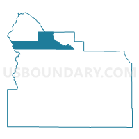
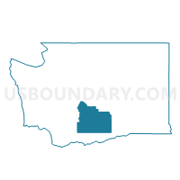
Nile Voting District, Yakima County, Washington
About
Outline

Summary
| Unique Area Identifier | 690253 |
| Name | Nile Voting District |
| County | Yakima County |
| State | Washington |
| Area (square miles) | 225.09 |
| Land Area (square miles) | 224.89 |
| Water Area (square miles) | 0.21 |
| % of Land Area | 99.91 |
| % of Water Area | 0.09 |
| Latitude of the Internal Point | 46.81111640 |
| Longtitude of the Internal Point | -121.19030920 |
Maps

Graphs
Select a template below for downloading or customizing gragh for Nile Voting District, Yakima County, Washington


Neighbors
Neighoring Voting District (by Name) Neighboring Voting District on the Map
- Voting District 02-058, Pierce County, WA
- Big Bottom Voting District, Lewis County, WA
- Cliffdell Voting District, Yakima County, WA
- E Naches Voting District, Yakima County, WA
- Manastash Voting District, Kittitas County, WA
- N Wenas Voting District, Yakima County, WA
- Rimrock Voting District, Yakima County, WA
Top 10 Neighboring County Subdivision (by Population) Neighboring County Subdivision on the Map
- Yakima CCD, Yakima County, WA (139,936)
- Northwest Yakima CCD, Yakima County, WA (8,252)
- Manastash Ridge CCD, Kittitas County, WA (5,238)
- Mount Rainier CCD, Pierce County, WA (3,406)
- Big Bottom CCD, Lewis County, WA (2,911)
Top 10 Neighboring Place (by Population) Neighboring Place on the Map
Top 10 Neighboring Unified School District (by Population) Neighboring Unified School District on the Map
- Ellensburg School District, WA (26,508)
- Eatonville School District, WA (12,084)
- Naches Valley School District, WA (8,078)
- White Pass School District, WA (4,080)
Top 10 Neighboring State Legislative District Lower Chamber (by Population) Neighboring State Legislative District Lower Chamber on the Map
- State House District 2, WA (163,707)
- State House District 13, WA (143,750)
- State House District 20, WA (141,029)
- State House District 14, WA (130,478)
Top 10 Neighboring State Legislative District Upper Chamber (by Population) Neighboring State Legislative District Upper Chamber on the Map
- State Senate District 2, WA (163,707)
- State Senate District 13, WA (143,750)
- State Senate District 20, WA (141,029)
- State Senate District 14, WA (130,478)
Top 10 Neighboring 111th Congressional District (by Population) Neighboring 111th Congressional District on the Map
- Congressional District 8, WA (810,754)
- Congressional District 3, WA (779,348)
- Congressional District 4, WA (774,409)
Top 10 Neighboring Census Tract (by Population) Neighboring Census Tract on the Map
- Census Tract 9752, Kittitas County, WA (5,238)
- Census Tract 31, Yakima County, WA (5,232)
- Census Tract 30.01, Yakima County, WA (4,584)
- Census Tract 701, Pierce County, WA (3,406)
- Census Tract 9720, Lewis County, WA (2,911)